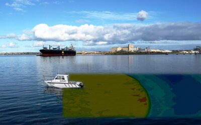
Water bodies cover over 70% of the planet. It’s crucial to understand the seabed and sub-surface topography in addition to developing ships that go across the ocean’s surface. Hydrographic Surveys, or underwater studies, are used to accomplish this.
Hydrographic surveyors, also known as hydrographers, are experts in data collecting, precise placement, and processing in both offshore and onshore marine environments, intending to improve navigational safety.
What is Hydrographic Survey?
The science of underwater measurement and feature description that affects maritime navigation, dredging, marine building, offshore oil exploration/offshore oil drilling, and associated operations is known as the hydrographic survey.
Hydrography is primarily done out for shallow water under authority concerns using sensors, sounds, or electronic sensor systems.
Things to Look Out While Conducting Hydrographic Surveys:
A hydrographic survey done correctly can be quite useful even in the murkiest conditions. Some of the factors to look out for areas listed below:
- Safety
Because the activities include exposure to a water environment and situations for which one must prepare, the first issue is safety: training and anticipation are the keys to safe practice. Technically, the project specifications are clearly those of the customer.
To ensure safe shipping on rivers, canals, and ports, a hydrographic survey is required. To address a wide range of needs, we must adjust our capabilities and procedures. A bathymetric survey, for example, might take many different forms depending on whether it’s for estimating dredging volumes, creating an accurate chart of a port or navigational area, or conducting a coastal protection survey over several kilometers of coastline.
- Proper Cleaning
Proper maintenance, operation, and care, like with all equipment deployed in the field in extreme situations, is important to the equipment’s long-term availability.
The increased influence of saltwater on hydrographic survey equipment necessitates thorough cleaning and maintenance.
- Environmental Conditions
When it comes to environmental circumstances, one of the most important aspects to consider when doing a hydrographic survey is the environment, as well as vessel stability, fuel efficiency, and ease of engine maintenance.
Another thing to think about is the Hydropod for multibeam systems and whether or not it needs to be recalibrated between survey sites.
- Regular Calibration Procedures
The principal maintenance is to be anticipated through frequent calibration processes and signal quality monitoring. Hydrographic survey equipment is rather resilient. A wide range of equipment is now available, ranging from low-cost plug-and-play systems with short life cycles to auto-calibrated, durable, and long-life cycle equipment.
The field operator’s academic background and continuous education are one of the most important maintenance procedures for any hydrographic survey equipment. E-learning, webinars, and other continuing education programs have been established or are being developed by all major equipment manufacturers, hydrographic offices, and regional hydrographic societies.
- Training
Hydrographic surveyors must be trained in order for them to understand how to utilize the equipment correctly and attain the best accuracies for data collecting, data processing, modeling, and volume/differential calculations.
Conclusion
Depending on the type of data generated, hydrographic surveys can be undertaken in a variety of ways. Preliminary reconnaissance of the surrounding area is essential before any survey can be carried out. The hydrographic surveyors will be able to predict the type of terrain to expect and adjust their equipment accordingly.


