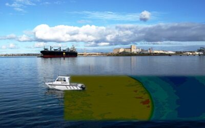
Do you know what the foundation of the science of Hydrography is? Bathymetric…!!! Yes, it is the foundation and a study of the base of water bodies like lakes, rivers, streams and oceans. If you are interested in Bathymetric Surveys, then you must know All about Bathymetric Surveys. This survey includes a large range of activities that fall under this survey, so let’s discuss it in detail.
What is Bathymetric?
The study of the base (like the floor) of the water bodies is called Bathymetric. Water bodies like lakes, rivers, streams and oceans have a floor that is important to observe and mapping in many important tasks. When one needs to know the depth of a water body, this survey conducts. Bathymetric Surveyors conduct this survey to detect many activities like water-quality studies, flood inundation etc. Different methods are used to conduct it: multi-beam and single-beam surveys, the Ecomapper Autonomous Underwater Vehicle, ADCPs and sub-bottom profilers.
Mainly two types of Bathymetric Surveys
Single Beam Echosounder (SBES) –
A single beam is used in Single Beam Echosounder to capture the data. A single beam is placed right below where the system is attached. Pre-defined line spacing, 2m, 5m, 20m are a single beam survey, and the size of these intervals determines the final resolution of the survey.
Multibeam Echosounder (MBES) –
In need of seafloor coverage, Multibeam Echosounder surveys are conducted. In this technique, 512 beams in a fan shape are attached under the boat that allows the system to capture up to 200,000 soundings per second. It is the best way to ensure maximum coverage of the seafloor.
Use of Bathymetric Survey –
- Flood Inundation
- The contour of Streams and Reservoirs
- Leakage, Scour and Stabilization
- Water-Quality Studies, Dam Removal
- Biological and Spill
- Storage and Fill In Reservoirs And Ponds
Use of Bathymetric data –
Bathymetric data is used in different applications such are –
- Hazard Detection and Debris Clearance
- Scouring and Asset Inspection of Bridges
- Under Keel Clearance
- Underwater Scanning with Multibeam Echo Sounder
- Safety of Navigation and Nautical Charting
- Dredging / Renourishment Support and Monitoring
- River, Creek and Estuary Surveys
- Search and Rescue or Reconnaissance
- Installation of Tide Gauge or Water Level Infrastructure
- Dam Asset Management and Reservoir Surveys
- Marine Habitat Mapping
- Sub Bottom Profiling
- Coastal and Foreshore Development
- Navigational Aid Positioning
Final Words…!!!
Well, here is an attempt to sum up all the important things about the Bathymetric Surveys. Your purpose may be different in getting such information whether you want to become a Certified Bathymetric Surveyor or conduct Bathymetric Surveys. In both of these needs, it is important to consult the best company near you with the same purpose to provide you satisfactory solutions based on the marine projects.


